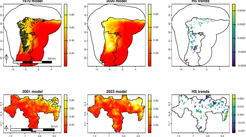
Our article “Ecotrends: an R package for estimating habitat suitability trends over time” presents an R package developed to streamline and strengthen the analysis of temporal trends in habitat suitability.
By providing standardized analytical methods, a fully reproducible workflow, and intuitive high-quality visual outputs, Ecotrends enhances transparency, comparability, and scientific rigor in ecological studies.
This tool supports researchers, practitioners, and conservation planners in detecting meaningful ecological patterns over time and making informed decisions for biodiversity management.
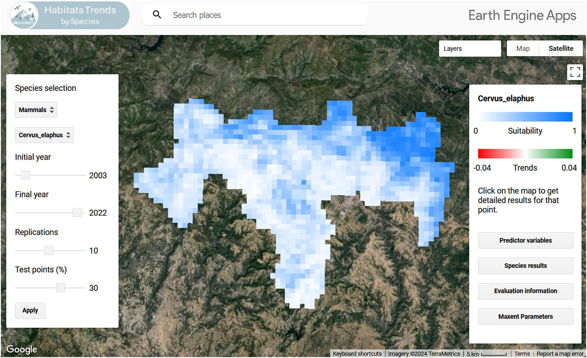
I contributed to the development of this work by assembling and processing time-series remote-sensing and species occurrence data,
integrating them within the Google Earth Engine-based application framework, and validating its capacity to analyse changes in species’ habitat suitability over time.
My efforts included data cleaning, script-writing for automated analyses of habitat-trend indicators, testing the user interface for the application, and documenting the workflow to support reproducibility.
These contributions helped ensure the tool is robust, user-friendly and suitable for supporting biodiversity monitoring and conservation applications.
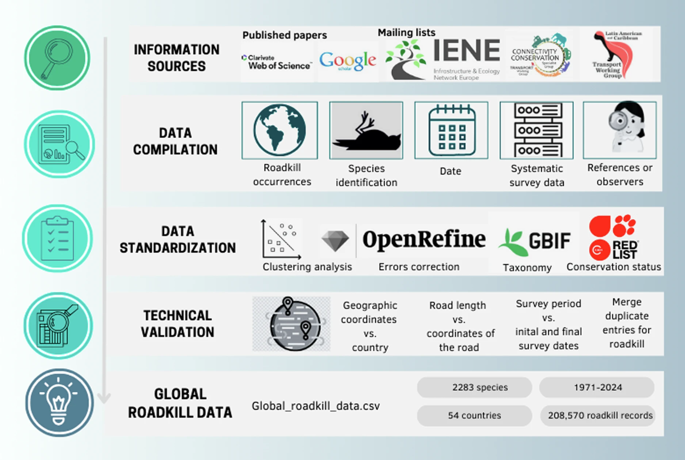
I contributed to this study by collecting and curating regional road-kill records, standardizing taxonomic and spatial information, and
verifying data quality to ensure accuracy and consistency within the global dataset. I also assisted in documenting metadata and validating the spatial proximity of occurrences to roads.
These efforts helped improve the dataset’s reliability and enhance its geographic coverage for global analyses of vertebrate mortality from vehicle collisions.
I'm the lead author of the publication titled "Assessing spatial and temporal trends over time in potential species richness using satellite time-series and ecological niche models", available in Biodiversity and Conservation (2024).
This study maps species richness trends (2001–2021) in SAC-MN (Portugal) using MaxEnt models and satellite remote sensing (GEE).
Based on 10,190 species records, we assessed potential species richness (PSR) and trends via the Mann–Kendall test.
Results show PSR increases in eastern/western areas but declines centrally, varying across taxa. This approach enhances
biodiversity monitoring for conservation planning.
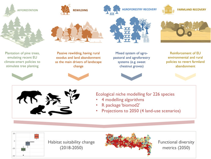
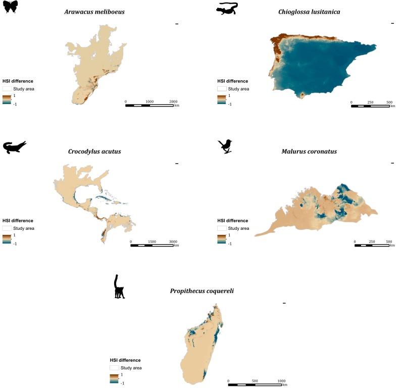
I've contributed to the publication titled "Dynamic shifts of functional diversity through climate-resilient strategies and farmland restoration in a mountain protected area", available in Environmental Management (2024).
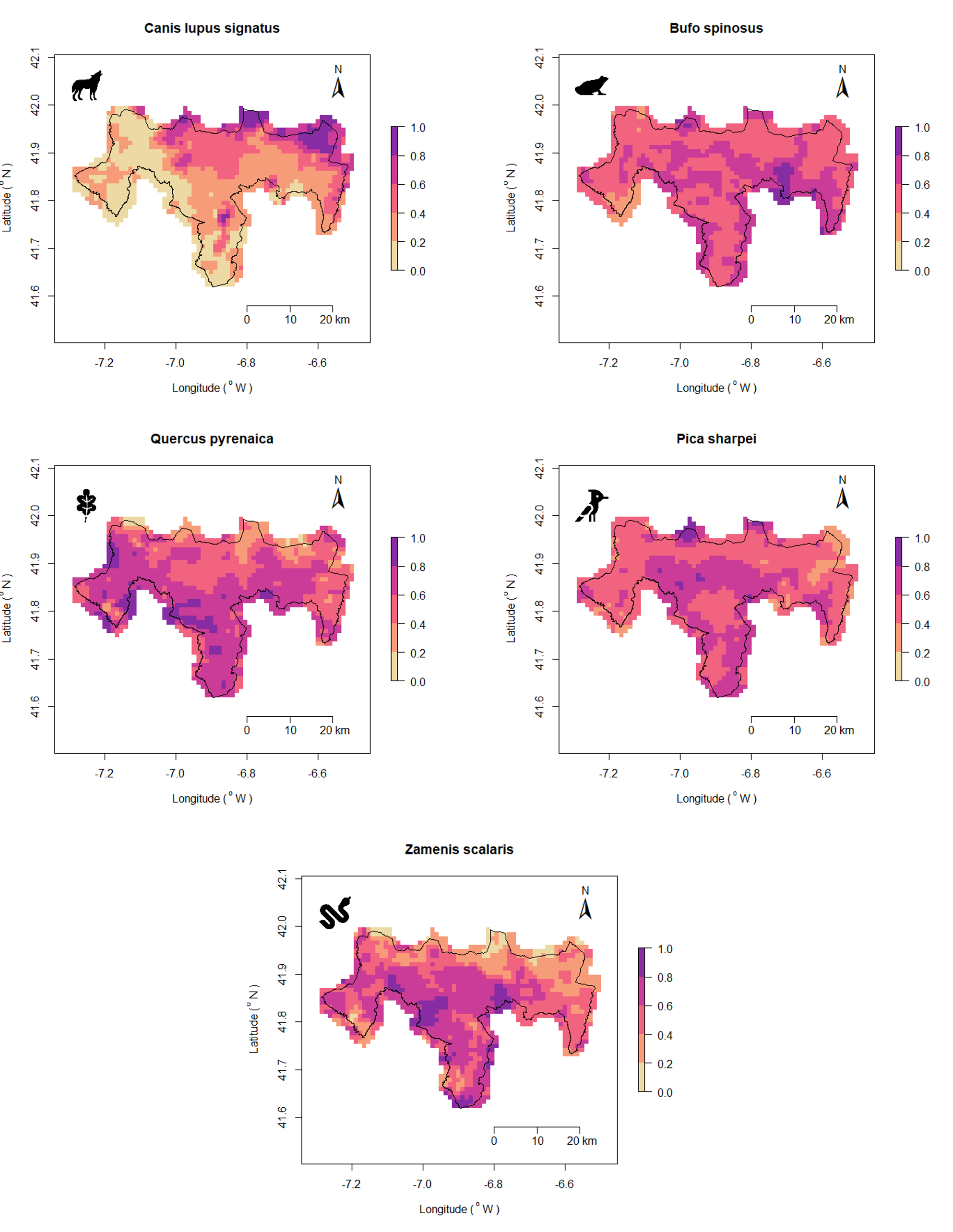
This study assesses LULC change impacts in Montesinho Natural Park (Portugal) using ecological niche models for 226 species. By projecting afforestation, rewilding, farmland, and agroforestry scenarios for 2050, we evaluate habitat suitability and functional diversity. Results highlight rewilding’s biodiversity benefits,
while agroforestry enhances landscape resilience. Integrating both strategies supports ecosystem services and conservation.
I contributed to the development of a spectral library in Montesinho Natural Park (Portugal), which led to the publication
to the publication titled "Spectral Library of Plant Species from Montesinho Natural Park in Portugal", available in Data (2024).
I've contributed to the publication titled "Ecological Niche Models using MaxEnt in Google Earth Engine: Evaluation, guidelines, and recommendations", available in Ecological Informatics (2023).
The paper introduces and evaluates initial MaxEnt Ecological Niche Models (ENMs) in Google Earth Engine (GEE),
highlighting GEE's speed and accuracy compared to MaxEnt software. It discusses statistical and spatial similarities between GEE and MaxEnt models,
addresses unavailable data in GEE models, and emphasizes the need for absent parameter integration for cloud-based ENMs.
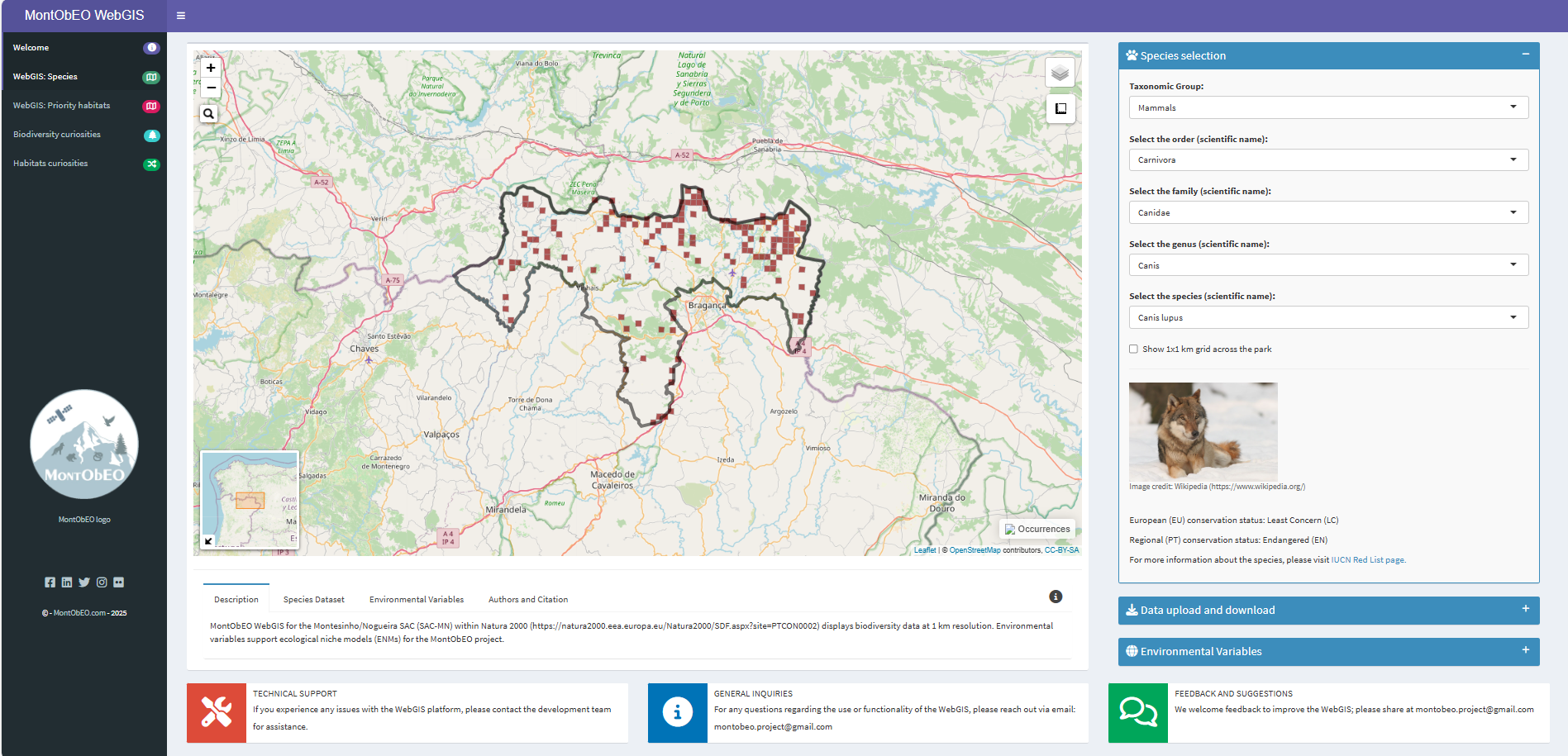
I spearheaded the publication titled "Biodiversity atlas of the special area ofconservation Montesinho/Nogueira,Portugal", available in Biodiversity Data Journal (2024).
The manuscript's focal points include addressing the biodiversity knowledge gap within special area ofconservation Montesinho/Nogueira (PTCON0002)
through an extensive data collection process, encompassing species occurrence records and
conservation status information sourced from regional (Portugal) and European levels. Moreover, we developed an accessible web-based
Geographic Information System (Web GIS) for seamless navigation. This article provides an in-depth account of the data
compilation and preparation process, alongside the design and development of our Web GIS, intended to raise awareness and
deepen understanding regarding the significance of conserving biodiversity within PTCON0002.
I have contributed to the publication titled "Time-series analyses of land surface temperature changes with Google Earth Engine in a mountainous region", available in Heliyon (2023).
The paper's highlights encompass an exploration of temporal trends in land surface temperature (LST),
the impact of seasonality on these trends, the influence of topography on LST,
and the adaptive responses of vegetation to maintain metabolic activities amidst seasonal variations.
These insights provide significant understanding of land surface dynamics and vegetation behavior within a mountainous context.
I've completed an MSc thesis titled "Using Google Earth Engine, ecological niche models, and a web geographic information system for biodiversity monitoring"
available in University of Porto's repository. The study focuses on the Montesinho/Nogueira SAC-MN, using SRS-ENMs in GEE to estimate potential species richness and developing a Web GIS for mapping species distributions.
This approach aids biodiversity conservation decision-making.